WHATCOM COUNTY, Wash. — Wind gusts upwards of 50mph were reported overnight between the evening of Tuesday, December 16, 2025, and Wednesday morning. Over an inch of rain was reported to have fallen during the same period.
Nearly 6,000 Puget Sound Energy (PSE) customer addresses in Whatcom County were reportedly without power at some point during the storm.
As of 8:45am, nearly 1,600 remained without power in Whatcom County. Areas to the south were hit much harder according to PSE.
Last night’s heavy rain and strong winds caused widespread power outages across our service area, with Island, Pierce, Skagit and Thurston counties hardest hit. Early morning reports from field crews are of a significant amount of damage, including wires down and whole trees that have uprooted. We currently have 18 substations and 31 transmission lines offline.
Advertisement
Click for more informationAdvertisement
Click for more information– Puget Sound Energy (December 17, 2025)


Wind speeds have been declining since peaking around 4am. A wind advisory warning of 40mph southwest gusts remains in effect until 10am.
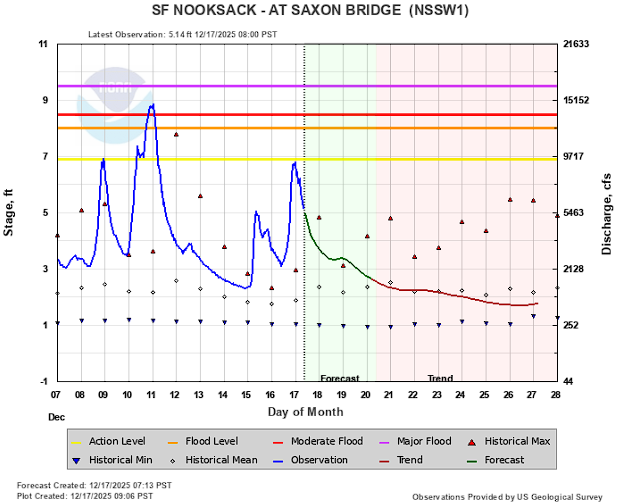
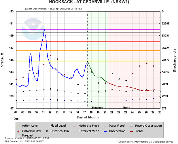
The Nooksack River level rose due to the heavy rains and, as of 9am, crested at the low end of action level at Saxon Road bridge and north Cedarville gages. It is forecast to crest above minor flood stage at the Ferndale gage.
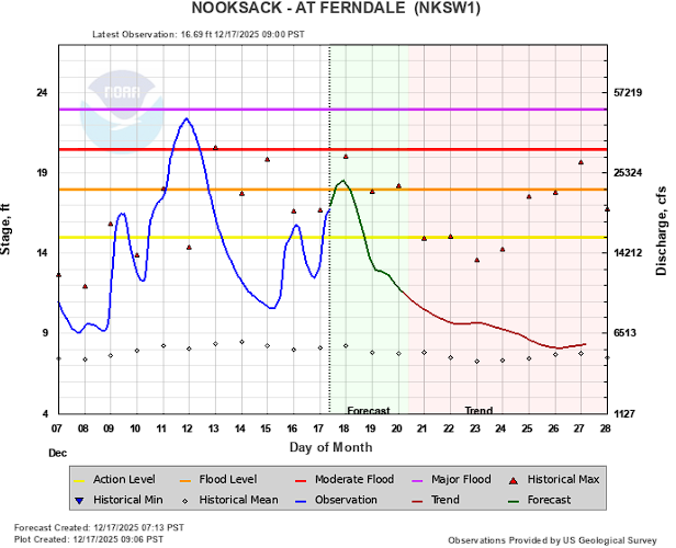
At 8am, a flood warning was issued for the Ferndale area.

Click for more information

Click for more information
The National Weather Service in Seattle WA has issued a Flood Warning for the following rivers in Washington…
Nooksack River At Ferndale affecting Whatcom County.
Recent rainfall is driving the Nooksack River back up again, including pushing it above flood stage for the Ferndale reach.
- WHAT…Minor flooding is forecast.
- WHERE…Nooksack River at Ferndale.
- WHEN…From this afternoon to early tomorrow afternoon.
- IMPACTS…At 18.0 feet, the river begins overtopping its banks within the City of Ferndale flooding low-lying areas within the City and low pasture lands along the river from near Ferndale downstream to the mouth.
ADDITIONAL DETAILS…
– At 7:45 AM PST Wednesday the stage was 16.4 feet.
– Flood stage is 18.0 feet.
– Forecast…The river is expected to rise above flood stage this afternoon to a crest of 18.5 feet late this evening. It will then fall below flood stage late tonight.Advertisement
Click for more informationAdvertisement
Click for more information


Rain and winds continue to be present in the local weather forecasts but not as heavy or as fast as was just experienced with this recent storm except for locations nearest the foothills. Those locations could see moderate to heavy rains Thursday, Friday, Saturday and/or Sunday.
Low temperatures are expected to begin falling below 40 degrees later this week as well although any precipitation that falls as snow is currently only expected to fall in the higher elevations.
Whatcom News readers are encouraged to stay up to date with current weather alerts and forecasts and air quality readings for their specific Whatcom County locations along with tide tables via the Whatcom News Weather page.
River level forecasts can change frequently so motorists and property owners are advised to monitor the Nooksack River level forecast.
Discover more from Whatcom News
Subscribe to get the latest posts sent to your email.