
8am update
Temperatures around the Ferndale remain at or below freezing while temperatures to the north, east and south have all risen above the 32° mark.
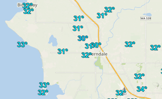
Source: Wundermap(R)
Well-traveled roads, especially at lower elevations, appear clear and wet. Overpasses and bridges should be approached with caution as they are most likely to have ice on the road surface. Lesser-traveled roads and sidewalks appear coated with compact snow and ice.
Conditions vary widely over short distances. Drivers should be alert for changing road conditions along their routes. For example, Main Street between Douglas Road and Church Road is relatively bare and wet but west of Church Road, Mountain View Road is covered with compact snow and ice.
There have been reports of single-vehicle crashes with vehicles leaving the roadway and into ditches and fences.

Click for more information

Click for more information
Original story
As of 6am Thursday, Ferndale area roads, and all other outside surfaces for that matter, are glazed by a thin layer of ice. Currently, there is no precipitation falling but a large moist weather system is arriving in the northern regions of western Washington, including Ferndale.
Temperatures are at or below 32° around the Ferndale area and at or above 32° around Bellingham. Concern for additional ice accumulations of up to 1/10-inch in the Ferndale area will continue until temperatures increase above freezing. The time between the arrival of the moist air mass and the transition to warmer temperatures will be marked by the forecast freezing rain and forecasters warn it may last into the afternoon.
National Weather Service forecasters say the weather system may increase southeast surface wind enough to temporarily end the northeast wind and get temperatures above freezing. But the official forecast temperatures are not far above freezing temperatures and that continues this afternoon through tonight.
There have been few reports of severe difficulties on the roads and all reports agree roads are slick in areas north of Bellingham.
City of Ferndale (COF) Public Works Foreman James Slaughter said Public Works trucks are out applying sand along COF priority routes (map below).

Forecasters warn another system arriving tomorrow is expected to cause a return of the northeast wind and drop temperatures back towards freezing. As a result, freezing rain is expected to return. Heavier precipitation and colder temperatures on Friday afternoon pose a greater risk of greater ice accumulation than what is expected today. However, ice accumulation should still be under 1/4″ both today and when freezing rain re-develops on Friday according to forecasters.
Discover more from Whatcom News
Subscribe to get the latest posts sent to your email.