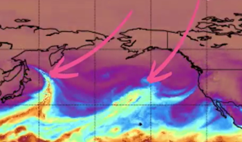
WHATCOM COUNTY, Wash. — Forecasters with the Seattle office of the National Weather Service said this morning, Wednesday, November 24th, to expect a series of 3 atmospheric river events, similar to what recently caused historic flooding of the Nooksack River along with road damage due to surging streams and creeks, over the next 7 to 10 days.
NWS forecasters say at least 3 atmospheric river events are forecast to impact western Washington. “While none of these events by themselves would likely result in widespread flooding, the cumulative effects of these storms will increase flooding concerns over the next week.”
TIMING (based on current forecasts)
First – arriving tonight (Weds.) and lasting into Friday
Second – arriving Saturday and lasting into Sunday
Third – arriving Tuesday or Wednesday and lasting through Wednesday
Current computer weather model runs are indicating between 1 and 2.25 inches of total rainfall for the Whatcom County lowlands during the first atmospheric river event.

Click for more information

Click for more information
On Saturday, a second wet and warm front is expected to stall over southern BC bringing moderate to heavy rain to the northern Cascade Mountains until weakening on Sunday. A third system is expected Tuesday or Wednesday again with high snow levels and heavy rainfall totals in the mountains.
Southerly and southeasterly gusty winds are also expected to accompany these weather systems. Wind advisories for Whatcom County appear possible during the second and third events.
Current Nooksack River level forecasts reflect the expected rising snow levels and heavy rains.
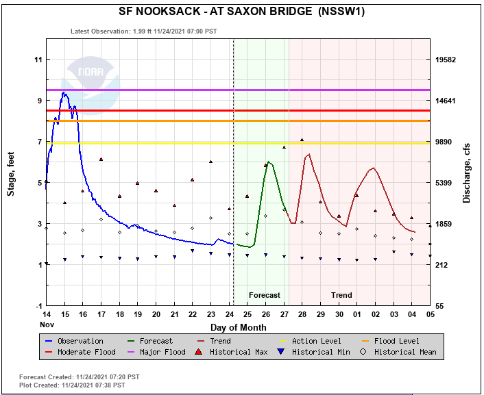
While the Saxon Bridge gauge location forecast levels do not reach “Action Stage” during these events, the Cedarville gauge location further downstream does.

Click for more information

Click for more information
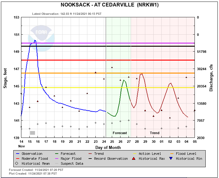
The Cedarville gauge location forecast does expect the river to crest 3 times over the upcoming days entering the “Action Stage” each time. The highest crest is expected at about 146.5 feet, the lowest point of the “Minor Flood Stage” range, on Sunday. This is about 4 feet lower than the crest level during the recent flooding event. At 146.5 feet, hydrologists with NOAA say, “The Nooksack River will cause shallow flooding of low pasture lands along the river downstream through Lynden.”
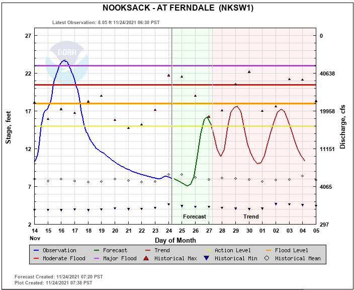
The Ferndale gauge location forecast also expects the river to crest 3 times over the upcoming days, entering the “Action Stage” while staying below “Minor Flood Stage.” The highest crest is expected to reach 17.5 feet late Monday or early Tuesday. This level is just below “Minor Flood Stage” which begins at 18 feet. Low-lying roads in the Ferndale area are frequently impacted when the river level reaches 15 feet or “Action Stage.” At 17.5 feet, hydrologists with NOAA say, “The river begins spilling over its banks into low pasture lands flooding some roadways that are not protected by levees including Marine Drive and Ferndale Road. The Nooksack River will overtop levees along Bertrand Creek and near Marine Drive, causing shallow flooding of low pasture lands along the river and additional roadways within the floodplain including Slater Road.”
Surface water flooding along with stream and creek flooding can also pose dangers to property and motorists. Experts advise being aware of the risks of driving through water over roadways and advise to turn around and take alternate routes to eliminate such risks.
River level forecasts can change significantly over time and Whatcom News readers are encouraged to monitor the latest Nooksack River level forecasts.
Whatcom News readers are encouraged to stay up to date with current weather alerts and forecasts and air quality readings for their specific Whatcom County locations along with tide tables via the Whatcom News Weather page.
Discover more from Whatcom News
Subscribe to get the latest posts sent to your email.