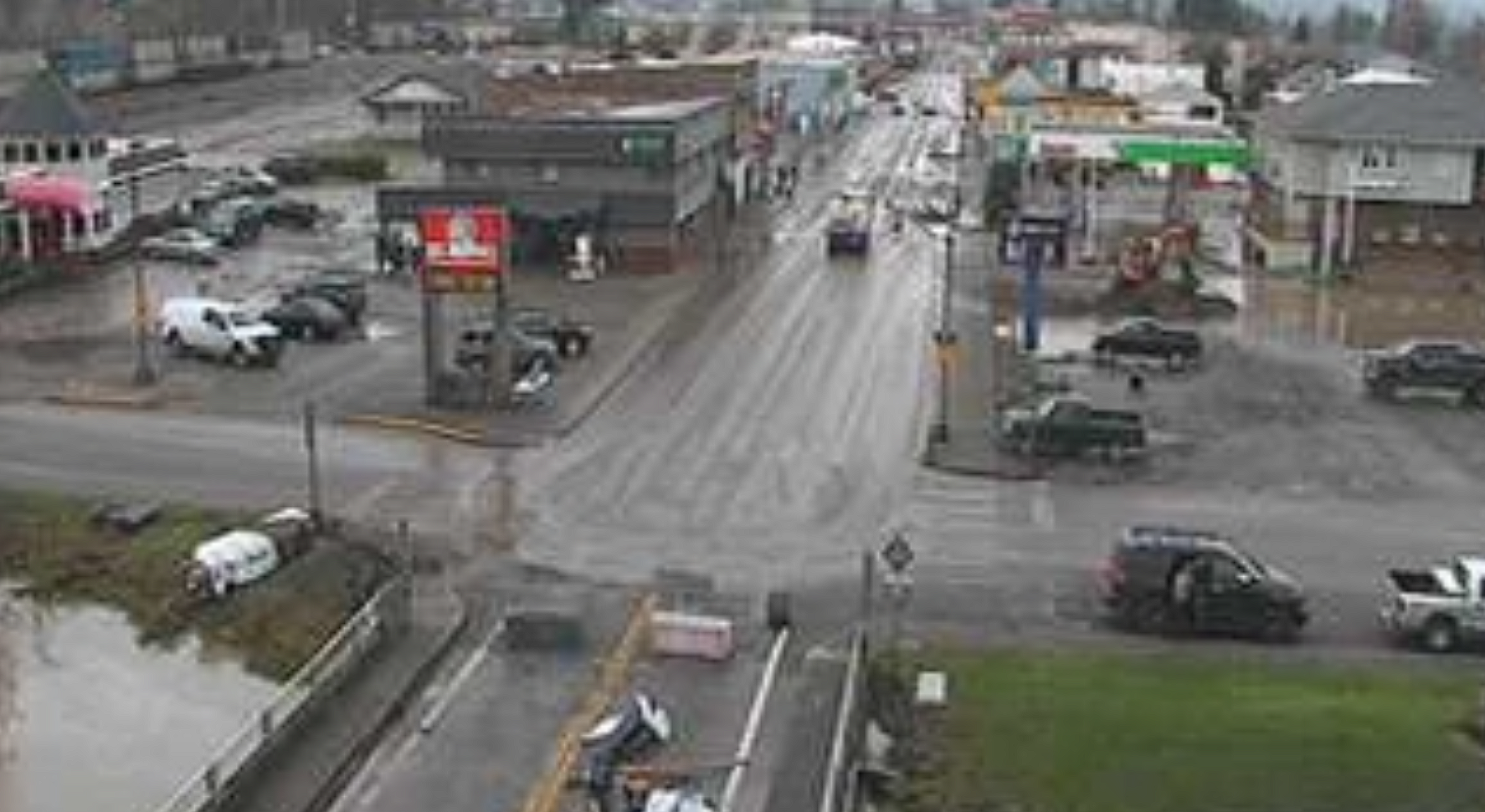
WHATCOM COUNTY, Wash. — As the Nooksack River recedes from cresting around moderate flood stage. Officials with the City of Sumas today, Saturday, December 13, 2025, lifted the evacuation order for residents and allowed them to return to their homes, although everyone else was asked to stay away. While water remains over many roads across eastern Whatcom County and areas around the Nooksack River in Ferndale, some closed roads have been reopened.
With milder weather this weekend, this is the time for impacted residents to clear out flood debris (especially before mold can set in.) There are three county debris management sites:
- Nooksack, Sumas, Everson area: Stremler yard, 9626 Swanson Rd (intersection of Swanson and Halverstick) 7 a.m. to7 p.m. daily
- Ferndale, Marietta area
- RDS Disposal, 4916 LaBounty Drive, Ferndale, 7:30 a.m. to 5:30 p.m.
- Republic Services, 1524 Slater Road, Ferndale, 7:30 a.m. to 5:30 p.m.
- Fourth drop-off site in north county is pending
When dropping off debris, please pre-sort: appliances and hazardous materials must be separated. Some debris cannot be accepted: tires or vehicles, asbestos, machinery or mechanical parts, woody debris or regular trash.
– Whatcom County Division of Emergency Management (December 13, 2025)
Advertisement
Click for more informationAdvertisement
Click for more information


Forecasters say to expect another round of wind and rain beginning Sunday evening.
A different story emerges Sunday night into Monday, when the next atmospheric river taking aim at the region. Snow levels will remain rather high at the onset (above 7500 ft), and rainfall amounts look be be on the order of around an inch for the lowlands and 2-4 inches in the mountains through late Monday, with the mountain amounts highest in the Cascades from around King County northward.
This would have the potential to bring prolonged or renewed flooding on many areas rivers. Gusty winds also are likely to increase with this frontal system with gusts reaching 30-40 mph remaining likely (>60% chance) through the coastal and favored windy locations in the interior. The pattern stays active and rather damp through much of the week ahead, but the arriving trough will bring snow levels dipping down to below the Cascade passes through the day Tuesday and to around 2500 ft Wednesday.
This will set the stage for potential heavy snowfall in the mountains during the midweek time period. Meanwhile, this will bring additional rainfall to the lowlands through much of the week ahead with a moist and active weather pattern remaining in place.
Advertisement
Click for more informationAdvertisement
Click for more information– National Weather Service Seattle office (December 13, 2025)


Wet trend continues in flood prone and affected areas. This weekend into next week, more rainfall is in store over the upcoming days for the already saturated Fraser Valley. The timeline is as follows: Minimal precipitation is expected today. However, a weather system will move into the area tonight and persist into Sunday. On Monday, another system arrives with a more significant push of moisture. Rain will intensify Sunday night and continue most of Monday. Rainfall amounts with this system are more similar to typical fall storms and will likely range from 30 to 60 mm [1.2 to 2.5 inches]. Strong winds gusting up to 80 km/h [50mph] will also accompany this system. Given the impacts from the recent atmospheric river and current vulnerability, rainfall warnings may be issued Sunday.
– Environment Canada (December 13, 2025)
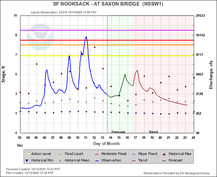
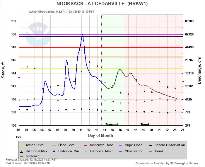
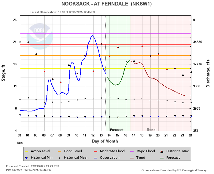
The current Nooksack River level forecast (see below) show the river cresting again midweek below action level in the east county and between action level and minor flood stage in the Ferndale area.

Click for more information

Click for more information
More unstable weather is being forecast through late December keeping rivers at elevated levels and soils saturated. This will increase the risk of flooding and landslides in the event of heavy rains.
River level forecasts can change frequently so motorists and property owners are advised to monitor the Nooksack River level forecast.
Whatcom News readers are encouraged to stay up to date with current weather alerts and forecasts and air quality readings for their specific Whatcom County locations along with tide tables via the Whatcom News Weather page.
Discover more from Whatcom News
Subscribe to get the latest posts sent to your email.