
A recent Discover Ferndale article about the risk of a tsunami to Ferndale and the surrounding area pointed out how to react to a sea-born natural disaster. But looking to the east at Mount Baker begs the question about what would happen if it erupted.
Mount Baker has been, in geological terms, recently very active. Eruptions and collapses have occurred most recently in 1843, 1854, 1858-60 and 1880. Also, in 1975 there were noticeable increases in steam and heat flow from the mountain. That increase in heat from the volcano has since subsided but could signal new activity below the mountain.
While unlikely any populated areas, including Ferndale, would be reached by lava flows following volcanic activity on Mount Baker, other devastating results of an eruption are flooding, landslides and ash fall.
Flooding often results from geologic events that suddenly melt the mountain’s snow and ice pack. As the water races off the mountain and down river valleys it picks up mud, trees and large debris creating a force that can take out buildings, roads and bridges along way. These events are called “lahars.” According to the US Geological Survey (USGS), Ferndale is considered to be in the Mount Baker lahar hazard zone.

Click for more information

Click for more information
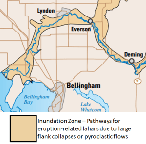
An eruption isn’t required for lahars to occur. Non-eruptive flank collapses (caused by earthquake, gravity, or other underground movements) are just as capable of causing destructive lahars.
It is possible for resulting lahars to cut off sections of the county due to their ability to wipe out roads and leave large piles of impassable debris. Lahars created by the Mount St. Helens eruption and flank collapse in 1980 were devastating and came close to taking out two Interstate 5 bridges 20 miles downstream.
So, what will happen and what should you do when there is an geologic event and a lahar warning is issued as a result? The following have been compiled from multiple sources:

Click for more information

Click for more information
Be Alert
-
- There will be an official tsunami evacuation siren
- Alerts will be issued on NOAA radio
- Emergency telephonic warnings will be issued
Know what to do
-
- Stay off the phone and do not call 9-1-1. Tying up phone lines slows down the notification process.
- Listen to NOAA and local radio stations for latest emergency information.
- Get to higher ground, especially away from the Nooksack River and its basin (the flat lowland area south of Main Street).

Click for more information

Click for more information
Know where to go
How will you know where to go when you hear the warnings? It depends on where you are. If you are north or east of the Ferndale Main Street bridge, you should get at least 1 mile away from the river. But after a lahar passes downtown Ferndale, the danger zone fans out with the railroad tracks on the east side and southern point of Elder Road on the west (see graphic above). This flat sea-level zone is also the tsunami danger zone.
If you are in the danger zone, get to the closest safe point outside the zone.
In the event of ash fall, wear goggles and use a dust mask. Keep pets and children indoors.
Additional resources
Discover more from Whatcom News
Subscribe to get the latest posts sent to your email.