
WHATCOM COUNTY, Wash. — Officials with multiple agencies around Whatcom County are advising motorists to stay off the roads if possible due to freezing rain coating roads in many areas this evening, January 6th.
As of 5pm, temperatures reported in Bellingham and to the south were in the 40s while areas only a few miles to the north remained in the upper 20s.
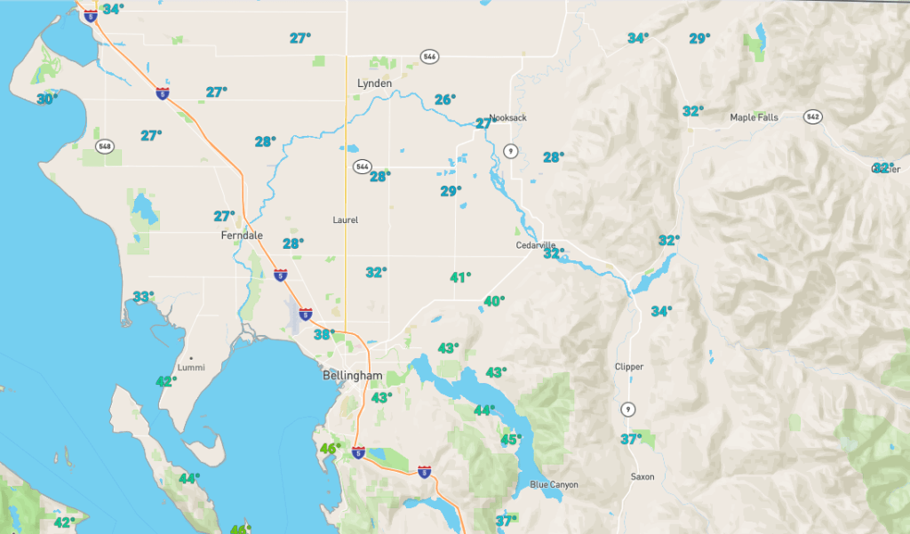
About 4:30pm, officials with the Whatcom County Public Works said, “We currently have freezing rain falling in Whatcom County, especially in the north county area. Please stay off the roads if you can tonight. Be extremely careful if you must be on the roads or driving home!”
Weather forecasts yesterday said to expect temperatures to climb into the 40s by early afternoon. Instead, the frigid Fraser Valley outflow winds appear to have kept the expected warmer surface air from reaching north county areas.

Click for more information

Click for more information
Much further to the south, Seattle was reported to have temperatures in the 50s, possibly setting a new record for the day.
While temperatures in the north county have been increasing since 6am this morning, the increase was 25% of what was expected, leaving temperatures well below freezing and creating a situation for the freezing rain. Precipitation is expected to continue into the early morning hours tomorrow.
A wind advisory will be in effect between 10pm today and 7pm tomorrow. The advisory warns of sustained south to southeast winds of 20 to 30mph with gusts between 40 and 45mph expected. Winds will become westerly by mid to late morning.
Discover more from Whatcom News
Subscribe to get the latest posts sent to your email.