WHATCOM COUNTY, Wash. — A flood watch issued by the National Weather Service Seattle office remains in effect through tomorrow morning, Thursday, January 13th.
The warning is due to current and forecast heavy rains and rising snow level in the north Cascade Mountains.
Excessive runoff may result in flooding of rivers, creeks, streams, and other low-lying and flood-prone locations.National Weather Service flood warning (January 12, 2022)
Rainfall totals by the end of today, Wednesday, are forecast to be 3 to 5 inches in the north Cascades with snow levels rising to 7000 to 8000 feet.

Click for more information

Click for more information
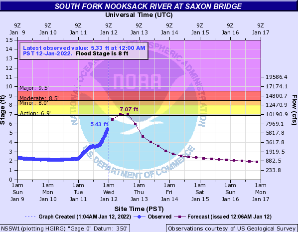
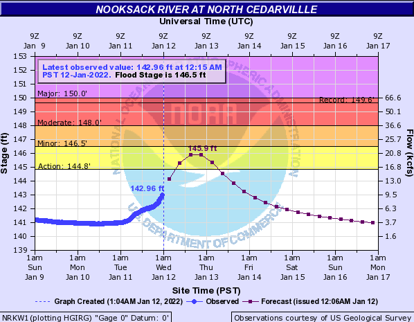
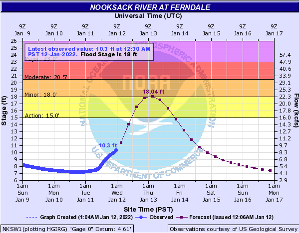
Current Nooksack River level forecasts at key locations continue to expect crest levels below flood stage range but near enough to warrant heightened awareness.
Everson Mayor John Perry said yesterday that he is expecting a minor flooding event and hopes that forecast continues until the current threat passes. But, in the event things end up being worse than expected, at least 1 precautionary measure is being taken.
Based on recent discussions with other cities, the County and consultants, installing sandbags along Emerson Road has been proposed to slow the flow of water heading north and reduce water levels at Main Street in Everson and beyond according to Perry.
Perry said that about 9am today, a crew comprised of Everson, Sumas, Nooksack and Whatcom County personnel will begin installing large sandbags (aka “Super Sacks”) along the west shoulder of Emerson Road. The north end of Emerson Road will be closed while this work is going on.

Click for more information

Click for more information

Approximate location of sand bagging work
Perry added that the sandbags would remain in place at least through the flood season.

By the time the river level reaches the 18-foot mark in Ferndale, as it is expected to do by early Thursday, motorists can expect the following roads to be impacted by water and debris and possible closures.
- Barrett Road/Paradise Road
- Ferndale Road between Marine Drive and Slater Road
- Ferndale Road between Slater Road and Ulrich Road
- Marine Drive between Lummi Shore Road/Drive and Rural Avenue
- Slater Road
River level forecasts can change frequently so drivers and property owners are advised to monitor the latest Nooksack River level forecast.
Discover more from Whatcom News
Subscribe to get the latest posts sent to your email.
