WHATCOM COUNTY, Wash. — Whatcom County Division of Emergency Management (DEM) issued a weather statement today, Thursday, November 3rd, regarding forecasts regarding an atmospheric river expected to bring heavy rain and winds to the Whatcom County area beginning tonight.
Citing current weather and hydrology (river level) forecasts, the statement provided the following information.
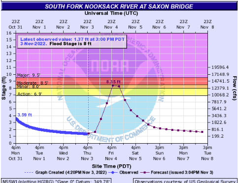
At this time, the river is expected to crest below flood stage at all forecast points, with the exception of the South Fork of the Nooksack at Saxon Bridge which may experience minor flooding. While the likelihood of flooding is low, all residents, particularly in low-lying areas that are subject to flooding, should be reviewing their flood preparation plans, be clear about exit routes, and prepare for the possibility of flooding. Whatcom County Division of Emergency Management Deputy Director John Gargett
DEM pointed to a weather statement issued by Environment Canada which said this atmospheric river event is expected to be similar in strength to the first of the season that arrived on Sunday, October 30th.

Click for more information

Click for more information
The statement went on to note, “Both Whatcom County Public Works River and Flood Division and the Whatcom County Sheriff’s Office Division of Emergency Management are actively monitoring conditions throughout the Nooksack watershed and are prepared to take action(s) should conditions change.”
As of 4:30pm on Thursday, the following National Weather Service alerts were in place for Whatcom County.
- Flood Watch (from 11pm Thursday through 5pm Saturday) – “A potent weather system will bring heavy rainfall to the region late tonight through early Saturday. This rainfall will result in rapid rises and potential for flooding along area rivers.”
- Wind Advisory (from 5pm Thursday through 8am Friday) – Southeast sustained winds of 30 to 40mph with gusts up to 60mph are expected
- Winter Weather Advisory (from 5pm Thursday through 5am Friday) – Snow expected above 4,000 feet with total snow accumulations of 6 to 12 inches and winds gusts as high as 40 mph.
As of 4:30pm on Thursday, the National Weather Service hydrology forecasts for 3 key points along the Nooksack River indicated the following expected crests.

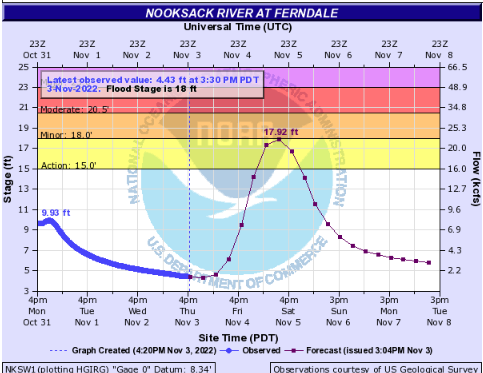
Road impacts can be expected in the Ferndale area after the river level reaches the 15-foot mark. Low lying roads near the river can be expected to have water and debris over them, leading some to be closed.
Whatcom News readers are encouraged to stay up to date with current weather alerts and forecasts and air quality readings for their specific Whatcom County locations along with tide tables via the Whatcom News Weather page.
River level forecasts can change frequently so motorists and property owners are advised to monitor the Nooksack River level forecast.
Discover more from Whatcom News
Subscribe to get the latest posts sent to your email.