Update 3pm: New details here as storm front gets closer.
UPDATE 9am: According to the NWS, the storm is moving along its path faster than expected. As a result winds are expected to pickup a couple hours earlier than initially predicted and the high wind warning has been moved from beginning at 2pm to noon.
Weather forecast models 12 hours ago indicated today’s predicted windstorm will be packing more of a wallop than the two prior. But the latest models are not as foreboding.
It is not quite halfway through the month of March yet Ferndale and surrounding areas have already endured two, soon to be three, significant wind events.

Click for more information

Click for more information
Today’s event forecast was dialed back slightly as the National Weather Service high wind warning was revised this morning. Earlier the warning told of gusts up to 70mph but that has been revised down to 60mph. This may or may not bring much comfort, as this was the forecast prior to Thursday’s windstorm which brought gusts in the 80mph range including one above 90mph in Ferndale.
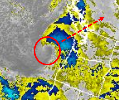
According to forecast models, the frontal system has been expected to track in a northeast direction across the south end of Vancouver Island. This path could cause the most extreme winds to occur around the Ferndale and surrounding area. But another model this morning indicated a path further south and east which would result is lesser impact in the Ferndale area. In addition, the low pressure is not expected to be as low as earlier forecast.
The frontal system could be seen forming in the GOES West Satellite infrared image from this morning.
The Ferndale area can expect the highest winds in the hours before and after 8pm today according to latest forecasts.

Click for more information

Click for more information
Puget Sound Energy issued a statement,
Crews are ready to respond and will do so as long as conditions are safe. High winds will slow and possibly stop response and restoration efforts.
As we get prepared, customers should get ready too. Make sure you have extra batteries, flashlights and emergency supplies on hand.
Discover more from Whatcom News
Subscribe to get the latest posts sent to your email.