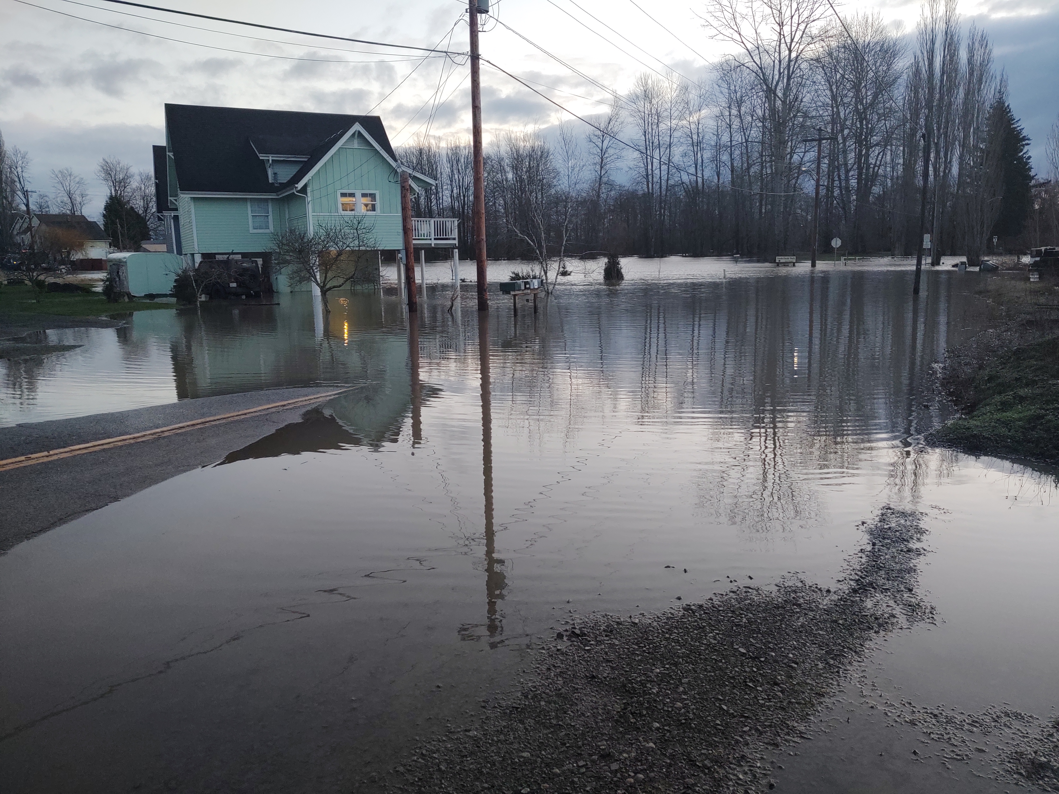
WHATCOM COUNTY, Wash. — The current National Weather Service (NWS) Nooksack River level forecast warns of minor flooding, primarily around the Ferndale area, beginning this evening, Friday, November 12th. The same forecast also warns of more significant flood risks after the weekend.
The NWS Seattle office reported today heavy rains from today’s atmospheric river event is primarily impacting central and southern regions of western Washington. This will spare Whatcom County from any significant immediate flooding but they also expect another atmospheric river event over the northern regions, including the North Cascades, Sunday and Monday. Heavier mountain rain from this system is expected to drive the Nooksack River level up further as indicated on current river level forecasts.
It appears likely road closures in low-lying Ferndale areas near the river will begin occurring late today, November 12th.
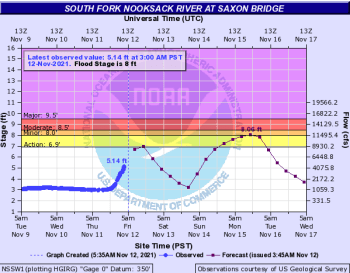
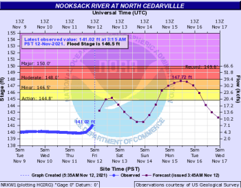
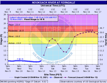
But more concerning are the river level forecasts for next week. According to the NWS Advanced Hydrologic Prediction Service, the following impacts are possible when the river reaches these levels at the different gauge points.

Click for more information

Click for more information
- Based on Cedarville gauge levels:
- at 146.5 feet – the river will cause shallow flooding of low pasture lands along the river downstream through Lynden
- at 147.3 feet – the river will cause widespread flooding of low farm lands along the river downstream through Lynden with swift water moving over several roads
- at 148 feet – the river will cause widespread flooding downstream through Lynden…with swift waters covering some farm lands and roads. Erosion may affect some river banks
- Based on the Saxon Bridge gauge levels:
- at 8 feet – the Nooksack River floodwaters will inundate much of the low farm lands along the river…with water over some roadways…including potentially Valley Highway (SR9) north of Acme
- at 8.5 feet – the Nooksack River flooding will be widespread with swift water covering farm lands and many roads. Valley Highway (SR9) north of Acme may be impassable. Erosion may affect some river banks
- Based on the Ferndale gauge levels:
- at 16 feet – the river begins spilling over its banks into low pasture lands flooding some roadways that are not protected by levees including Marine Drive and Ferndale Road
- at 17 feet – the Nooksack River will overtop levees along Bertrand Creek and near Marine Drive, causing shallow flooding of low pasture lands along the river and additional roadways within the floodplain including Slater Road
- at 18 feet – the river begins overtopping its banks within the City of Ferndale flooding low-lying areas within the City and low pasture lands along the river from near Ferndale downstream to the mouth
- at 20 feet – the river will flood additional areas within the City of Ferndale including low-lying residential areas and roads including Washington Street, Portal Way and Second Avenue
- at 20.5 feet – the Nooksack River will overflow levees and banks along the east bank of the river from Hovander Park downstream to Marietta, causing widespread flooding from near Ferndale downstream to the mouth…with swift waters in residential areas and over farm lands and roads…erosion may damage some river banks
The following roads have typically been impacted by water and debris over the roadway and/or closed after the river level passes the 15-foot mark at the Ferndale gauge:
- Barrett Road/Paradise Road north of Main Street
- Ferndale Road between Marine Drive and Slater Road
- Ferndale Road between Slater Road and Ulrich Road
- Marine Drive between Lummi Shore Road/Drive and Rural Avenue
There is potential for a speed reduction on and/or closing Slater Road between LaBounty Drive and Ferndale Road after the river passes the 17-foot mark.
River level forecasts can change quickly and drivers and property owners are advised to monitor the latest Nooksack River level forecasts.
Discover more from Whatcom News
Subscribe to get the latest posts sent to your email.