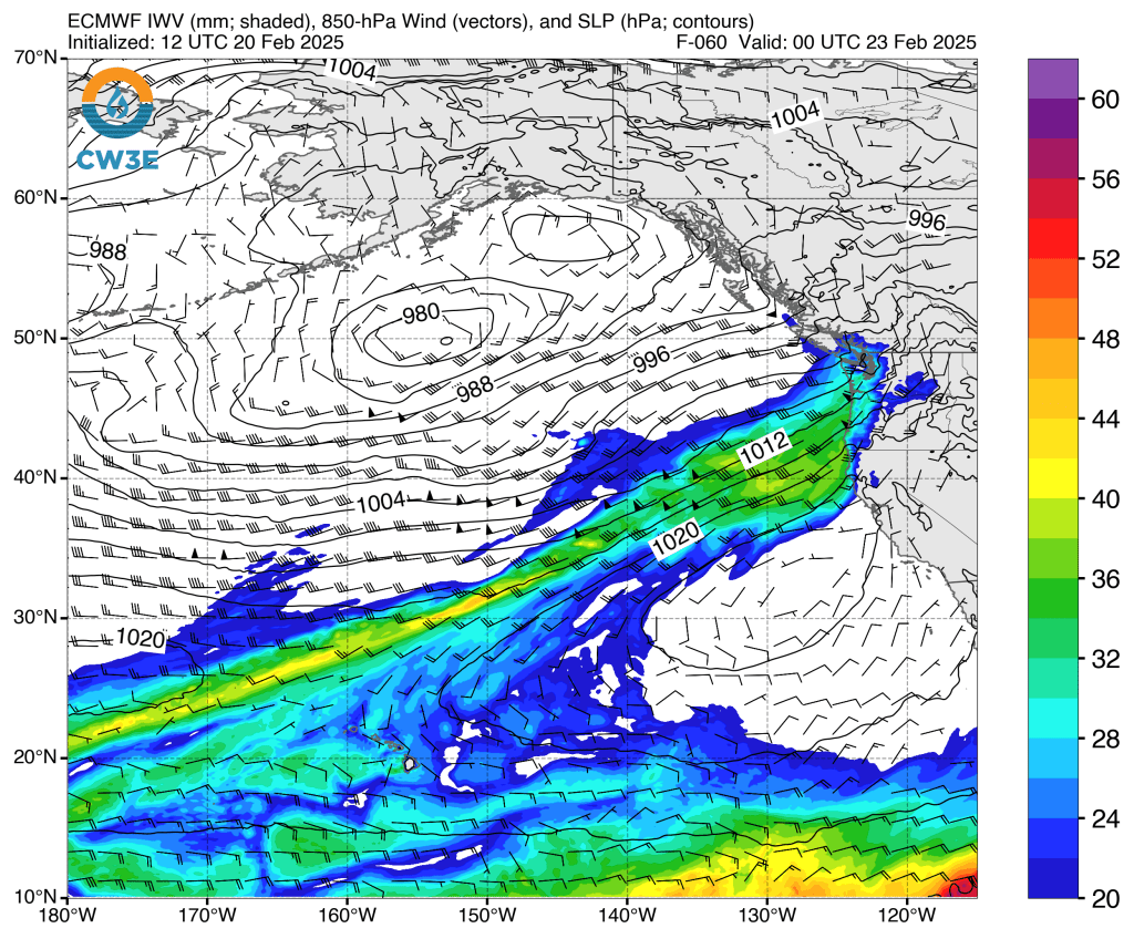
WHATCOM COUNTY, Wash. — Forecasters with the Seattle office of the National Weather Service issued a hydrologic outlook statement today, Thursday, February 20, 2025, due to an expected series of storms that will impact western Washington beginning Friday and continuing through Tuesday.
A series of storms will begin to impact western Washington on Friday and continue through Tuesday. The next storm on Saturday will have heavy rain at times as will a third storm right on its heels Sunday.
Precipitation amounts could be 3 to 8 inches storm total with snow levels rising above 6000 feet. With moderate temperatures now and warmer temperatures to come, this will also result in a some snow melt at low to mid elevations. These factors will combine to result in a potential for river flooding. At this time the most likely flood severity will be minor flooding.
There is also a Flood Watch out for Mason County, including the potential for moderate flooding on the Skokomish River.
Advertisement
Click for more informationAdvertisement
Click for more informationThe most likely areas for river flooding will be for rivers flowing off of the central and southern Washington Cascades, the Olympics, and in southwest Washington. Urban and small stream nuisance flooding and rainfall-induced shallow landslides will also be possible.
– National Weather Service (February 20, 2025)

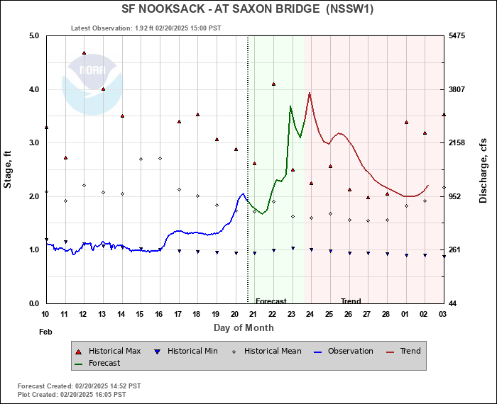
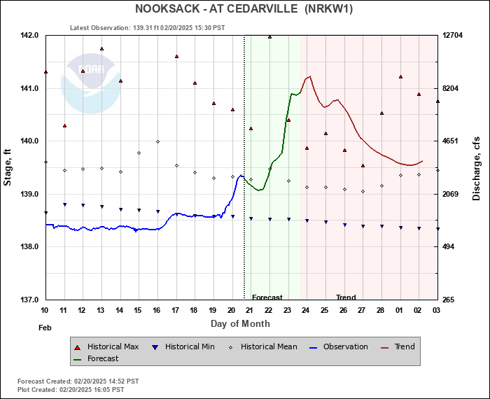
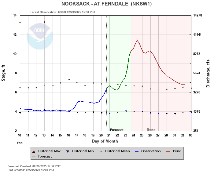
Current Nooksack River level forecasts show the river is currently at seasonably low levels. A noticeable increase in the river level is likely but, due to the low starting point, crests are expected to remain well below flood stages.
Currently forecast daily high temperatures and rainfall amounts for locations around Whatcom County are as follows.
Location Fri Sat Sun Mon Tues Bellingham 48/0.58″ 51/1.08″ 52/0.91″ 53/0.34″ 50/0.50″ Lummi Island 47/0.37″ 51/0.83″ 52/0.77″ 51/0.13″ 50/0.29″ Sandy Point 49/0.16″ 53/0.47″ 54/0.49″ 54/0.32″ 52/0.39″ Birch Bay 47/0.61″ 51/1.15″ 52/0.97″ 53/0.34″ 51/0.50″ Blaine 48/0.60″ 51/1.15″ 53/0.97″ 54/0.34″ 52/0.50″ Point Roberts 46/0.60″ 49/1.13″ 49/0.96″ 49/0.34″ 49/0.50″ Ferndale 48/0.45″ 52/1.22″ 53/1.01″ 54/0.34″ 52/0.50″ Laurel 49/0.46″ 53/1.22″ 54/1.01″ 54/0.34″ 52/0.50″ Lynden 48/0.67″ 52/1.37″ 53/1.13″ 53/0.34″ 51/0.50″ Sumas 47/0.73″ 52/1.53″ 52/1.20″ 53/0.34″ 51/0.50″ Everson/Nooksack 49/0.67″ 53/1.37″ 54/1.13″ 54/0.34″ 52/0.50″ Maple Falls 47/0.68″ 50/1.49″ 52/1.08″ 54/0.34″ 50/0.50″ Glacier 46/0.80″ 49/1.43″ 49/1.33″ 49/0.67″ 46/0.68″ Deming 49/0.61″ 52/1.58″ 54/1.11″ 55/0.34″ 52/0.50″ Acme 47/0.71″ 50/1.16″ 50/1.11″ 51/0.34″ 48/0.50″ Sudden Valley 45/0.71″ 48/1.16″ 49/0.93″ 49/0.13″ 47/0.29″
Whatcom News readers are encouraged to stay up to date with current weather alerts and forecasts and air quality readings for their specific Whatcom County locations along with tide tables via the Whatcom News Weather page.
River level forecasts can change frequently so motorists and property owners are advised to monitor the Nooksack River level forecast.
Discover more from Whatcom News
Subscribe to get the latest posts sent to your email.